Trail On foot San Bernardino Verbano - X03 - Ponte Casletto - in La Piana - Photo

X03 - Ponte Casletto - in La Piana

Tous les sentiers balisés d’Europe GUIDE+

© OpenStreetMap contributors
Length
Length
12.9 km
Max alt
Max alt
975 m
Uphill gradient
Uphill gradient
1263 m
Km-Effort
Km-Effort  
28 km
Min alt
Min alt
402 m
Downhill gradient
Downhill gradient
766 m
Boucle
Boucle
No
Signpost
Signpost
Creation date :
2022-02-15 08:53:01.157
Updated on :
2022-03-01 06:49:40.613

(0 Reviews)

On foot
On foot
6h22
Difficulty : Medium

Scan this QR Code to open this trail in the SityTrail application

FREE GPS app for hiking

Logo SityTrail SityTrail

IGN / Geographical institutes

Download SityTrail from the App Store Download SityTrail from Google Play

Logo SityTrail SityTrail World

The world is yours!

Download SityTrail from the App Store Download SityTrail from Google Play Download SityTrail on Huawei AppGallery

About

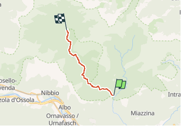
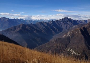
Trail On foot of 12.9 km to be discovered at Piemont, Verbano-Cusio-Ossola, San Bernardino Verbano. This trail is proposed by SityTrail - itinéraires balisés pédestres.

Description

Attention: steep and exposed paths, short rocky passes of II° , a few without chains. Relation with photos (click on → Web site) mantained by Danilo (danbag)

Symbol: red marks after Orfalecchio to in La Piana

Elevation profile

Positioning

Country:
Italy
Region :
Piemont
Department/Province :
Verbano-Cusio-Ossola
Municipality :
San Bernardino Verbano
Location:
Unknown
Start:(UTM)
459952 ; 5093372 (32T) N.

Trails nearby

Trail On foot Mergozzo - A58 - Mergozzo - Linea Cadorna - Mont'Orfano vetta - Photo
On foot
GUIDE+

On foot

Easy
Mergozzo, Piemont, Verbano-Cusio-Ossola, Italy
4.8 km | 10.6 km-effort
2h 24min
No
Trail On foot Miazzina - R03a Cappella Fina bivio R03 - Bivio R05 tra Cappella Porta e Cornala - Photo
On foot
GUIDE+

On foot

Easy
Miazzina, Piemont, Verbano-Cusio-Ossola, Italy
4.4 km | 6.4 km-effort
1h 27min
No
Trail On foot Cambiasca - R03 Cambiasca - Pian Cavallone - Pizzo Marona - Monte Zeda - Photo
On foot
GUIDE+

On foot

Difficult
Cambiasca, Piemont, Verbano-Cusio-Ossola, Italy
16.1 km | 36 km-effort
8h 14min
No
Trail On foot Verbania - R01 Verbania Trobaso - Unchio - Motto di Unchio - Pian di Les - Cossogno - Photo
On foot
GUIDE+

On foot

Easy
Verbania, Piemont, Verbano-Cusio-Ossola, Italy
4.7 km | 7.1 km-effort
1h 36min
No
Trail On foot Mergozzo - A56 - Mergozzo - Sentiero Azzurro - Mont'Orfano vetta - Photo
On foot
GUIDE+

On foot

Easy
Mergozzo, Piemont, Verbano-Cusio-Ossola, Italy
5.1 km | 11.2 km-effort
2h 32min
No
Trail On foot Cossogno - P11 - Cicogna - Cima Sasso - Photo
On foot
GUIDE+

On foot

Easy
Cossogno, Piemont, Verbano-Cusio-Ossola, Italy
5.2 km | 16.4 km-effort
3h 43min
No
Trail On foot Cossogno - P06 - Cicogna - Varola - Curgei - Pizzo Pernice - Photo
On foot
GUIDE+

On foot

Easy
Cossogno, Piemont, Verbano-Cusio-Ossola, Italy
4.3 km | 15.1 km-effort
3h 26min
No
Trail On foot Cossogno - BOVE - Sentiero BOVE - Photo
On foot
GUIDE+

On foot

Very difficult
Cossogno, Piemont, Verbano-Cusio-Ossola, Italy
28 km | 67 km-effort
15h 12min
No
Trail On foot Miazzina - R03 - Sentiero BOVE tratto Pian Cavallone Monte Zeda - Photo
On foot
GUIDE+

On foot

Easy
Miazzina, Piemont, Verbano-Cusio-Ossola, Italy
5.9 km | 14.7 km-effort
3h 20min
No


Close
My subscriptions